 Ampliar Mapa
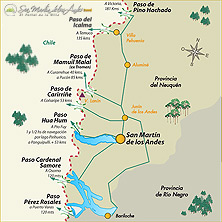
El Paso International Border "HUA HUM"
General location:
Ampliar Mapa
El Paso International Border "HUA HUM"
General location: The Midwest of Argentina, Neuquén Province - A 659 mt. above sea level - A 42 km. Northeast of San Martin de los Andes (31,690 inhabitants), Neuquén, Argentina - Une land and lake by Initial Provincial Route 48, Argentina, and International Route 203, Chile, and then address the Hua Hum ferry sailing on Lake Pirihueico by about 2 hours, until Puerto FUY - The nearest important Panguipulli (3,400 inhabitants), 30 km.
El Paso International Border "PEREZ ROSALES"
General Location: Southwest of Argentina, Black River Province, Department Bariloche, Spot Lago Frias - Communicates to Argentina with the X Region of Chile, through the National Highway 237 and National Highway 225 Argentina, Chile - Une localities Lake Frias to 58 km. San Carlos de Bariloche, Argentina and Peulla, Chile at 26 km.
El Paso International Border "Cardinal Antonio Samore"
General location: The Midwest of Argentina, Neuquén Province - Department Los Lagos, Spot The Corner - Communicates to Argentina with the X Region of Chile, through the National Highway 231 and National Highway 215 Argentina, Chile - the Une Villa La Angostura locations (6,000) to 53 km., Argentina with Entre Lagos (4,000 inhabitants) 40 km., Chile - Main economic activities: Agriculture and Tourism - Resorts near: San Carlos de Bariloche, Argentina - Villa La Angostura, Argentina - National Park "Nahuel Huapi", Argentina
El Paso International Border "Carirriñe"
General location: The Midwest of Argentina, Neuquén Province - to 1,176 mt. above sea level - A 63 km. west of Junin de los Andes (18,500 inhabitants) and 100 km. San Martin de los Andes (31,690 inhabitants), Neuquén, Argentina - Une overland through initial Provincial Route 62, Argentina and International Route 201, Chile - The nearest important Liquiñe (15,000 inhabitants), 30 km.
El Paso International Border "Mamuil Malal"
General location: The Midwest of Argentina, Neuquén Province - A 1227 mt. above sea level - 60 km. Junin de los Andes (18,500 inhabitants) and 105 km. San Martin de los Andes (31,690 inhabitants), Neuquén, Argentina - Une overland through initial Provincial Route 60, Argentina, and International Route 111, Chile - The nearest important Curarrehue (2,400 inhabitants), 40 km.
El Paso International Border "Icalma"
General Location: Northeast Squadron (-) 32 "Aluminé" Neuquén Province - Communicates to Argentina with Chile, through the Provincial Road 13 - Join the towns of Villa Pehuenia (1,030 inhabitants), Argentina and Icalma (1,600 inhabitants), Chile - Nestled in the urban area of ??"Villa Pehuenia" and "La Angostura" on the shores of Lakes "ALUMINE" and "Moquehue" at the foot of the volcano "BATS MAHUIDA"
El Paso International Border "Pino Hachado"
General location: The Midwest of Argentina, Neuquén Province - A 1884 mt. above sea level - Communicates to Argentina with Chile - Join the towns of Las Lajas (5,000), Argentina and Liucura (700 inhabitants), Chile